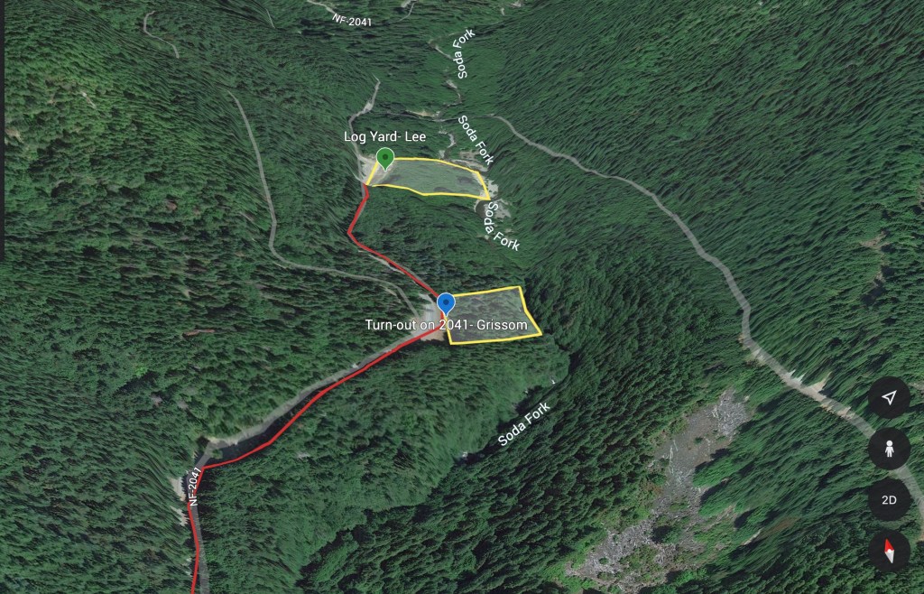
My search is now transitioning from research and planning to boots on the ground searching. So that I’m not randomly walking around the woods, I’ll be using the facts and the analysis of the same, the theory of the crime and my prior map work to find the locations. From the map, I’ve narrowed done my search box to about a 1 mile length of Soda Fork Rd.
Key facts that inform the on the ground work are that 1) Lee and Grissoms’ belongings were found within 1/4 mile of each other; 2) logging operations cut short the first search for Lee; 3) their belongings were found by loggers. From the theory of the crime, I’m starting from a belief that Rodney was murdered first, followed by Karen at a second location, 1/4 mile away. I can also reasonably interpret that the loggers who found the belongings, 5 years and 1/4 mile apart found them while on a bathroom break. People who work in the woods tend to stay on the job site instead of randomly wandering around since the foreman isn’t paying for them for that.
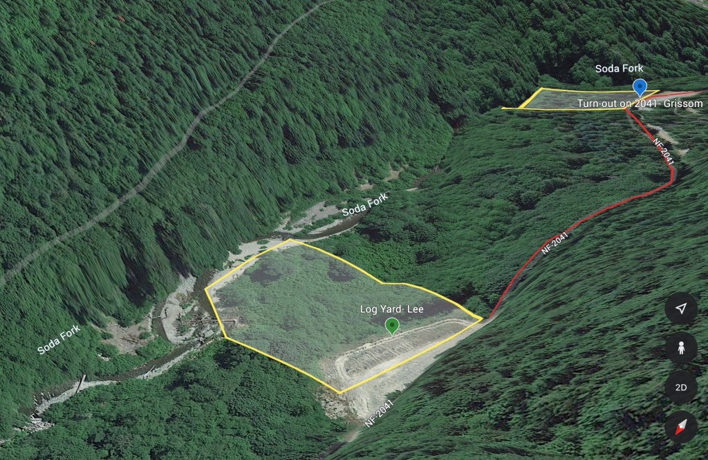
The goals of my first site survey, on 15 May 2023, were to determine a drive time from the Shari’s in Lebanon to Soda Fork, then find suitable locations along the identified length of Soda Fork that is within Section 19 and that support the “two crime scenes” and “found by a logger relieving himself” theories. One fact that had me puzzled was the “logging operations” that cut short the first search for Karen. The right or east side of the road is protected riparian zone along Soda Fork and the left side is the Federally protected Menagerie Wilderness. My question was how to square “logging operations” in an area where tree felling was unlikely to occur.
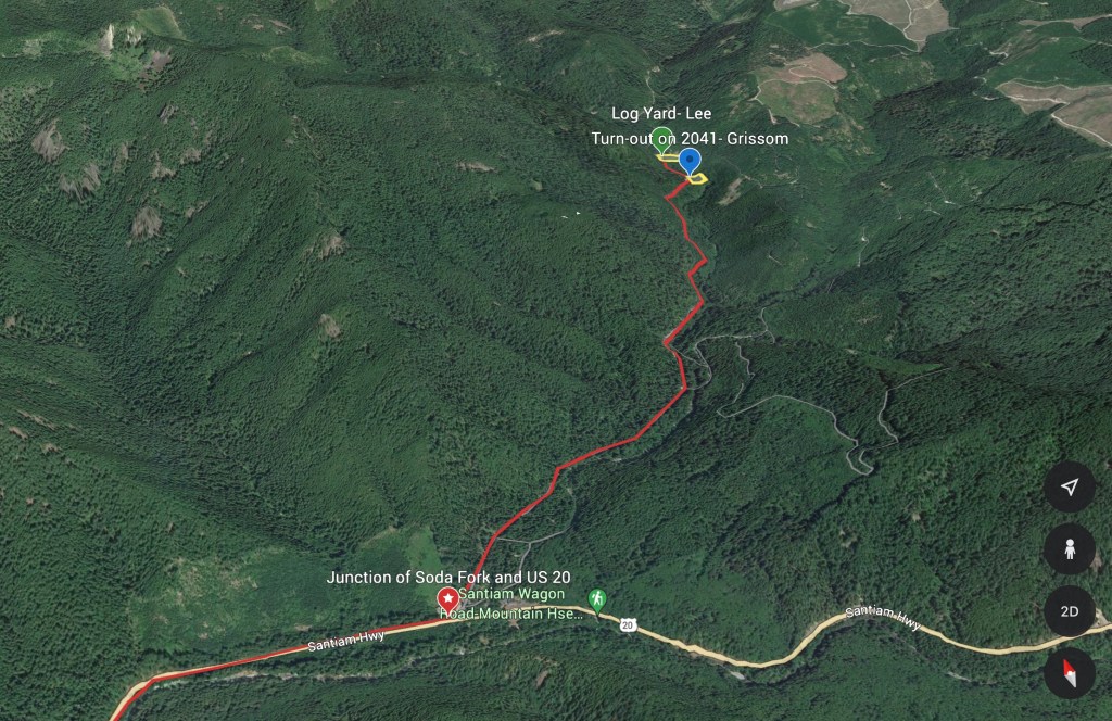
I began the drive from the Shari’s parking lot, and it took about 50 minutes on the dot to reach Soda Fork Rd. I pulled onto the logging road, opened my GPS and set a tracker and began the drive in. After driving about a mile from US 20, I reached the boundary for Section 19, and began scanning the side of the road for pull outs. The first three pull outs were barely worth the name, as they were about 4 feet wide and more useful for pulling over to let an oncoming log truck pass by. The hillside also dropped sharply away to the creek bed, which made them seem less likely for bathroom breaks.
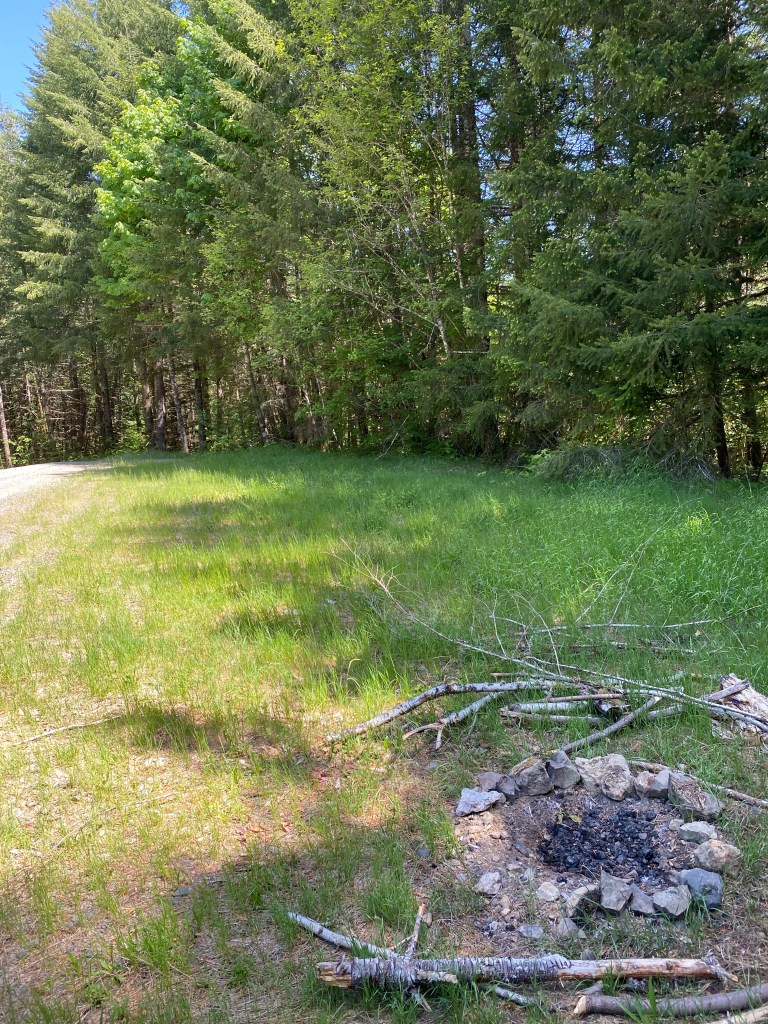
The next pull out was approximately 25 feet wide from the road to the wood line, had two fire pits and could have hosted 5-6 pickups at any given time. I pulled over, parked and walked the wood line. Very quickly I found a path from the pull out that went down a short incline to a flat, level spot. This bench was about 10-15 feet below the grade of the pull out, and my truck was not visible from that location. From the bench, the hillside dropped away again, with two natural lines of drift leading down the slope. I plugged a waypoint into my GPS as this was a likely location.
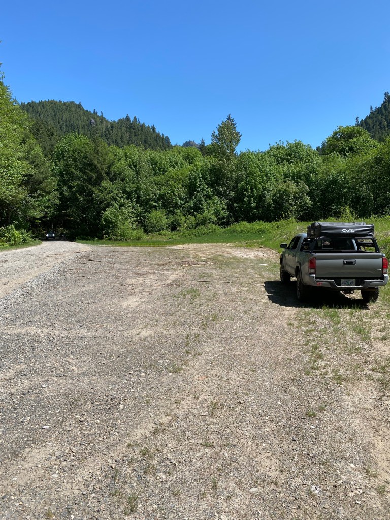
Returning to my truck, I reset the odometer and drove forward, looking for a pullout approximately 1/4 mile ahead. I exited the wood line and the road passed by a former log yard, exactly 1/4 mile from the previous location. That’s when it snapped together- the yard was the logging operation, and Karen’s belongings were found somewhere behind it. The yard consisted of a bulldozed flat section about 50 yards wide from the road to a berm. The berm rose about 10 feet, was about 50 feet wide with a rutted track along the top. The last 20 feet of the top before the wood line proper had started to grow in with Armenian blackberry, but there was still a well worn footpath to follow. This path went down the backside of the berm to another flat bench on the hillside. This bench was obscured from the road by the berm and the brush. Were there a row of stacked logs on top of the berm, that spot would be completely invisible. This was also entered into my GPS as the Lee Site.
I drove back to the first pullout and realized I had found both locations. The documented facts, analysis and theory all fit the ground. I walked the footpath to the bench, and with my truck out of site, and feeling the breeze from the creek below, it became inescapable that this was the probable location were Rodney Grissom was murdered. Looking up into the trees, a deflated, mylar children’s birthday balloon was twisting and righting in the wind. This became the Grissom Site.
I spent some time walking up and down the hillside, marking possible grave sites with surveyor flags and GPS waypoints. I returned to the log yard, now etched as the Lee Site. I walked up the berm, down the path to the bench, with Marlene Gabrielsen’s chilling account echoing in my head. I stood on the bench, looking at an otherwise unremarkable patch of alder scrub, but feeling the reverberation of the crime that had occurred there 46 years earlier.
It took 5 minutes to drive from the Grissom Site to US 20. I doubted those two kids, heading in the opposite direction and flush with being on an adventure, would have noticed how far from the pavement this bathroom break was.

2 Comments