Lidar is a type of ground scan using pulsed lasers to measure the ground. In Oregon, you can find the Oregon Lidar Consortium on the Department of Geology and Mineral Industries (DOGAMI) webpage. It is an open source lidar imagery database for the state. Lidar works similar to radar (radio waves in the air) or sonar (sound waves in water) in that laser light is emitted, bounces off the ground or objects on the ground and is returned to a sensor. The resulting sensor data is then rendered into an image.
I am analyzing the imagery as a supplement to my analysis of topographic maps, aerial photographic surveys and my own on-the-ground developed knowledge of this stretch of Soda Fork Rd. The lidar imagery is providing a more finely grained view of the topology of the hill side, and this informs my search plan for this year. The topographic maps would indicate that this area has a very moderate elevation change from the road to the stream, but the lidar confirms my own observations about the actual steepness of this hillside.
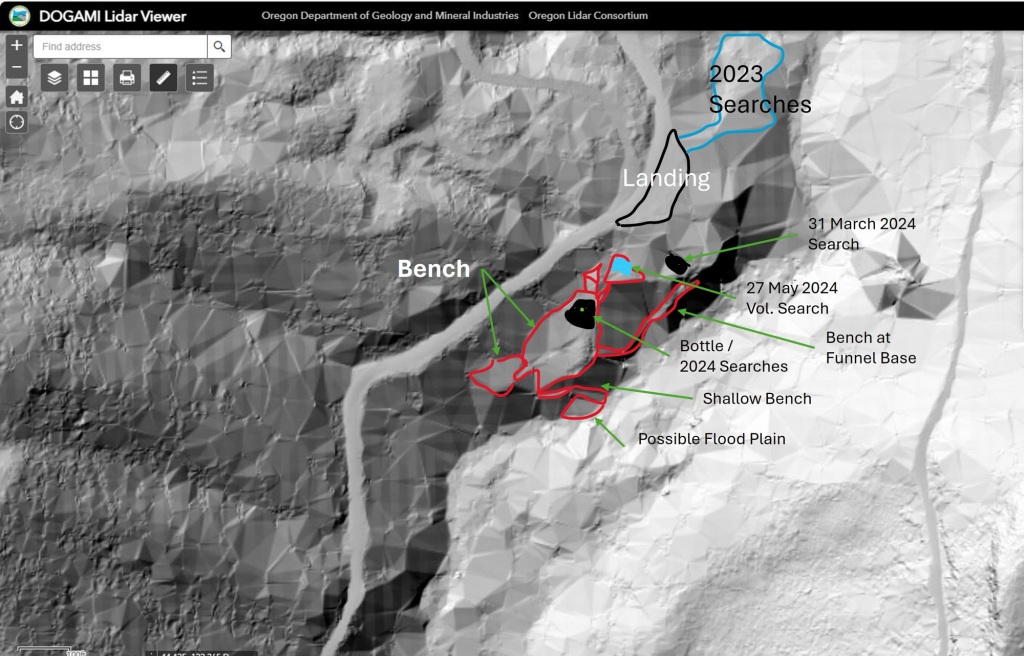
The lidar imagery also shows benches and funnels in the terrain that the topographic map does not. I’ve outlined those benches in red, and you can see the funnels leading from and to them in the darker greyscale of the imagery. In fact, the most visible funnel is the one below the turquoise shaded area that was searched on 25 May and 15 June. There might also be a way to skirt the south edge of the funnel to get to the narrow benches at the bottom.
The lidar, in concert with the 1982 BLM aerial photo-survey, also confirms something that has limited or frustrated prior searches by LCSO. The original reports of regarding the location where Karen and Rodney’s clothing and belongings were found are very general. We have a map sheet name, Upper Soda, the BLM section number 19 and a general and vague description of 1/4 mile down a rugged hillside from a logging landing, in an area of second growth timber and thick vegetation. Without a GPS grid to really nail down each location, finding a center point to work from is impossible. This is why I have resorted to a “brute force” hands and knees grid search. Using the shape of the terrain to inform how debris and hopefully remains have moved with water flow should help narrow down probable locations to search.
Topographic maps of the area can also confuse the search effort. In addition to the current FS 2041 road, annotated on the maps is a second road labeled Soda Fork Road, running parallel to and west of the 2041 road. Based on a map recon alone, one might think that “Soda Fork Road” was abandoned once the 2041 road was cut, thereby altering where to look along the road for a landing.
However the lidar imagery confirms the 1982 aerial photo-survey in this regard. The road network hasn’t;t changed over time. The current 2041 Road is the same as the “Soda Fork Road” listed in the original reports, and the road sign at the junction of US20 and FS 2041 still bears the name “Soda Fork Rd”. The lidar shows no abandoned road running parallel to the current one and this is true from the US20 junction to the log yard. You can see another, long abandoned landing along a spur road that splits from the 2041 Rd at the landing I am working out. That landing is next on my list to explore in case that is the one referenced in the original reports.
