Please enjoy this video tour of the Alternate Grissom site. In an added bonus, you can hear me decide in real time that I’m going to need some equipment to deal with that slope.
Author Archives: Ryan Auclair
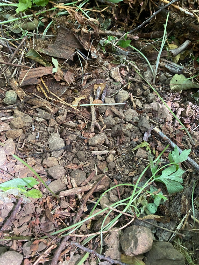
7 October 2023 Ground Search at the Lee / Grissom Site
After my rest break over the past two weeks, I got back on the search at Soda Fork Rd. After closing out the landing or Alternate Lee site on 16 September, I received word from a very reliable and knowledgeable person that the bone recovered on 17 June 2023 was of animal origin. While that was disappointing to say the least, it reopened the Lee / Grissom site to me. My personal rule is that if I uncover remains, and they aren’t ID’d as animal origin, I stay out of that area to avoid contaminating the scene. Since the site is open again, I went back out and restarted the ground search.
Since we are now into Western Oregon rifle deer season, I have added some blaze orange to my kit. Hopefully this will prevent Cletus from putting a .308 sized hole into my center of mass. I brought my blaze orange TRCP cap and my navigation / admin panel from my SAR load out.

I started the ground search at the same depression where I located the bone last time. I worked my way around the depression, removing debris and clearing the floor of the pit. After finishing that area, I began ground searching to the north.

Based on contemporary news accounts, Karen’s items were found in an area of active logging operations. While searching the forest, I definitely found evidence of prior logging operations in the area.


I located a black trash bag under the leaf litter. I carefully slit the top, but the bag was empty. Based on statements made by Ackroyd during interrogations about the disappearance of Rachanda Pickle, I decided to really search the immediate area around the bag. Despite clearing the forest floor to bare earth, there was nothing of note to report.


I continued ground searching to the north, until I encountered a swampy area that is an intermittent stream that empties into Soda Fork Creek. I spent the remainder of my time exploring the area south of the swamp and along the creek. There is a rather large flat bench that sits about 30 feet above the creek bed, and that bench cliffs out in a steep drop to the water. This bench will form my eastern search boundary, with Soda Fork Rd being the western boundary.

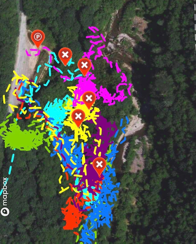
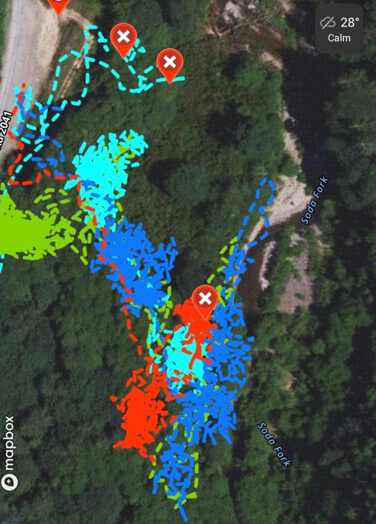
The three X waypoints running across the northern end of the day’s track represent the swamp, with the blue line representing the intermittent stream. The three waypoints running along the east denote the bench that sits above the creek. The bench above the creek will be my next area to search. It is approximately 1/4 mile from the road, and is at the end of a fairly easy line of drift to walk. My plan is to start with my feet hanging over the cliff, and to ground search forward from there.
An Autumn Update, and closing out the 6/17 Search
My apologies for the lack of updates over the past two weeks. After my 72 hour SAR training weekend, I need a rest break after a rather strenuous summer capped off with that training event. I re-started searching at Soda Fork on 7 October, search report to follow.
While I have not heard from an official source, a person I trust let me know that the bone recovered on 6/17 was determined to be of animal origin. Disappointing is one way to describe that, but this is something I am used to in this effort.
On the good news side, that reopens the Lee / Grissom site to me, and that is where I spent yesterday. I also gave the Alternate Grissom site a light search around the edges, before determining that I will need some equipment in form of ropes, anchor points and a harness to search that slope safely. There is a video tour of the Alternate Grissom site ready to post as well.
16 September Site Survey of the Alternate Grissom Site
Before I begin describing the site survey of the Alternate Grissom site, I want to outline my methodology for why I had designated the two locations the Grissom site and Lee site.
When I was able to locate the correct section 19 on the Upper Soda map sheet, my next step after that was to develop a theory of the crime. Based on what I learned about John Arthur Ackroyd, his MO, victim profile and other data points, it is my belief that he murdered Rodney first, before murdering Karen. It is also my belief that in order to accomplish this, he would need to split the kids apart. He would risk one or both escaping if he tried to murder both kids simultaneously. Also, given that loggers found each set of clothing, I also believed that the loggers were on a bathroom break in the wood line when the clothes were found.
Based on Marlene Gabrielsen’s account, and the context of Soda Fork Rd, it is my belief that he split the kids by saying he needed a bathroom break on the drive, drove up Soda Fork Rd, pulled over somewhere in Section 19, and Rodney followed him into the woods. This would split the kids apart, allow Ackroyd to kill Rodney with Karen contained in the truck and would allow Ackroyd to exploit “capture shock” and drive a 1/4 mile ahead on Soda Fork so that he could sexually assault and murder Karen away from Rodney’s body.
With that theory, I completed a site survey of Section 19, Soda Fork Rd. I believed that Rodney would be killed at the first turn out, and then Karen a 1/4 mile further north along the road in another turn out. Driving the road through the section, I noted that of the 4 turn outs in Section 19, the first two were more like scrapes to allow a pickup to pull to the side while a log truck passed by. Neither of the first two seemed like likely places to stop for a bathroom break, for either Ackroyd or for the loggers that eventually found their clothing.
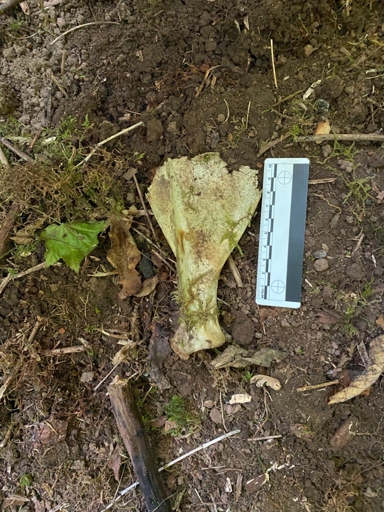
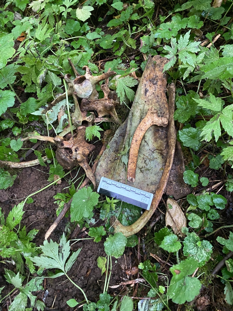
After closing out the Lee site earlier, I decided to revisit my assumptions about the two sites. I have spent between 30-40 hours on my hands and knees clearing the forest behind what I thought was the Lee site. I have found one bone fragment that was from an animal pelvis, and one fragment that may be from a radius, tibia or fibia. It only took me about 3 hours at the presumed Grissom site to locate human remains.
By finding potential human remains at the Grissom site, I have one “known” location. The presumed Lee site is a 1/4 mile north on Soda Fork Rd, and matches the description given in police reports and contemporary news accounts. However, without a GPS coordinate, or a more definitive description, I may be incorrect with that location. I decided to examine a pull out 1/4 mile south of the Grissom site. This would make the “Grissom” site the new “Lee” site, and the location further south and closer to US20 as the alternate “Grissom” site. The map below should add some clarity to the text description
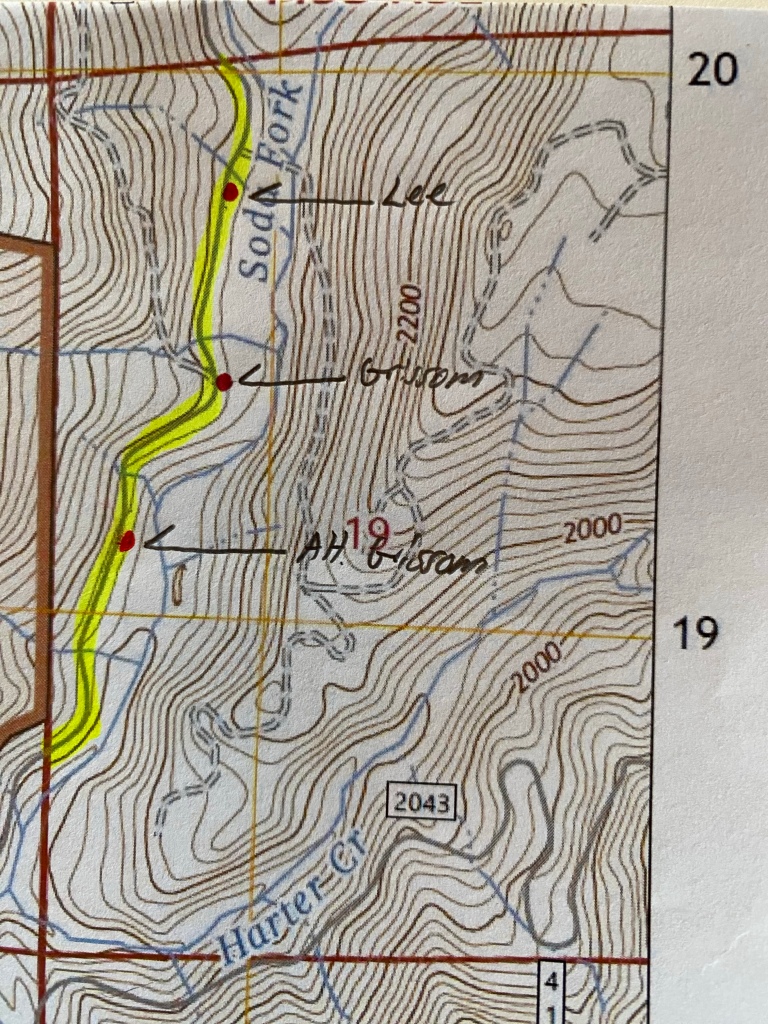
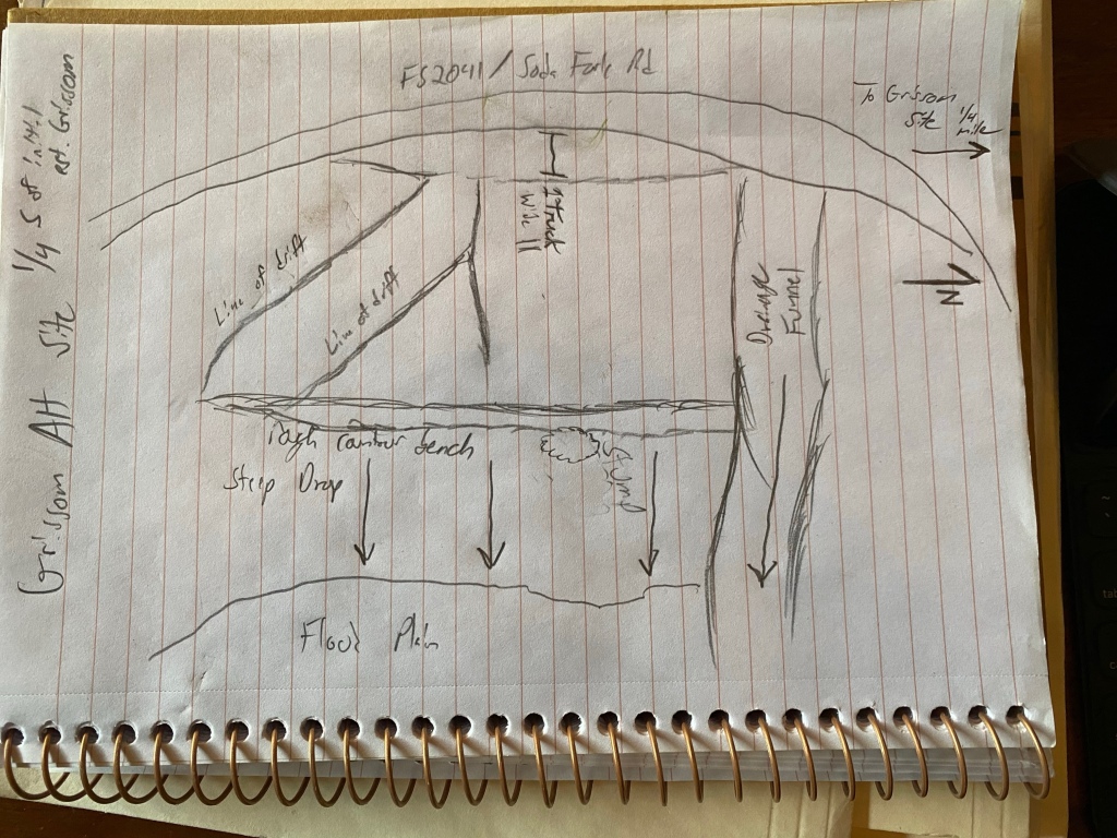
I drove from the Lee site to the original Grissom site, reset my odometer, and drove to the next pull out to the south. The next pull out was almost an exact 1/4 mile from the Grissom site. The scrape on the side was wide enough for my pickup to fit without being in the road. I hopped out, notebook and pencil in hand to start the survey.
There were two lines of drift leading from the pull-out into the forest. Each line ran roughly parallel to the other and ended downslope on a narrow bench that ran north to south, parallel to the road. Below the bench was a steep hillside that flattened out a bit as it neared the creek bed. At the northern end, the bench terminated in a large drainage funnel that would channel quite a bit of water down slope when it rained.
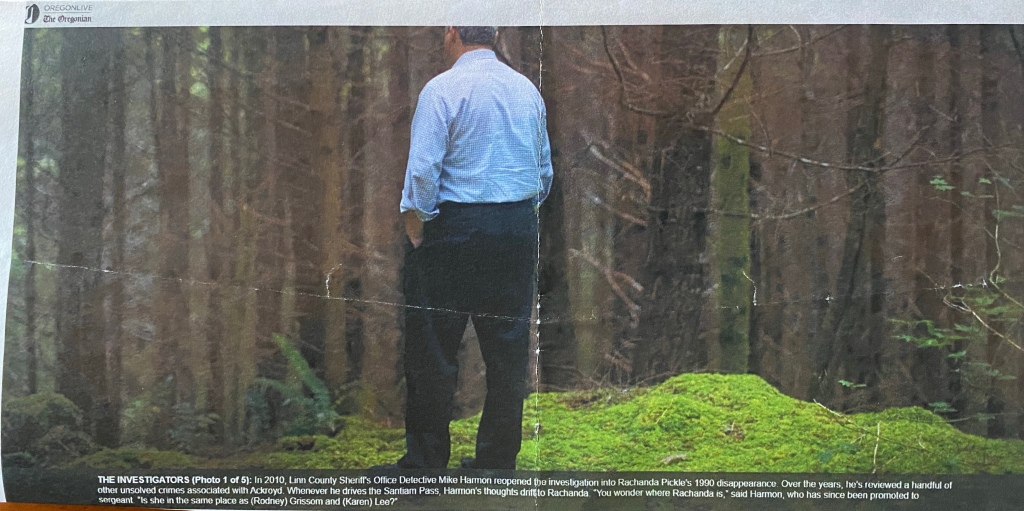
Based on the context of the location and the survey, this will be my next search area. It also lines up with another data point that I hadn’t been able to square with my previous research and site surveys. Noelle Crombie included a photo of Mike Harmon, taken by Beth Nakamura in the original “Ghosts of Highway 20” series. In that photo, Det. Harmon is said to stand near where Karen and Rodney’s clothes were found. However, without any distinct features, and that it had a rather generic description, I just assumed it had been a candid photo taken while Det. Harmon was guiding the reporters to different crime scenes associated with Ackroyd. However, it does appear that the photo was taken at the Alternate Grissom Site.
I plan on searching this location next. I incorrectly identified the original sites, but managed to be lucky in that one was correct. I can now offset from that correct location to this site. Hopefully, I will be successful here.
16 September Ground Search and Closing Out the Lee Site
Yesterday was my final ground search of the Lee site for the season. I searched to the north of the devil’s club thicket that I searched on 2 September. I entered the wood line from the northern line of drift, near the areas I had searched on 22 May and 30 June 2023. My goal for the day was to overlap with the thicket search on 2 September and then go over the area to the east and north.
I cleared the northern portion of the thicket, overlapping with the search on 2 September. This was another hands and knees to stomach and elbows search through the undergrowth. I uncovered nothing of note, but it was worth the effort to clear the north end of the thicket. I turned my attention to pushing east, searching between the previously cleared alder grove and the stream bank.
This was flood plain of scrub alder, maples, devil’s club and native Oregon blackberry and salmon berry vines. Judging by how the alders and maples were growing, with their branches swept almost parallel to the ground and pointing in the direction of the creek’s flow, it became apparent that this area is inundated yearly. I did notice a path through the underbrush, very low but distinct. Getting onto my stomach, I followed it into a mountain lion den.
Thankfully the den was empty when I arrived and stayed that way until I departed. The Glock loaded with .40 cal hollow points and the auto-opening knife felt very comforting to have in that moment. The den was worth entering and excavating because it was full of bones. I spent about an hour in there, on my stomach, sorting through deer bones and fragments.
I crawled out of the den and continued my search until I reached the creek bank. Standing up, I then searched north along the top of the bank, noting how flooding had eroded the bank back about 50 feet, creating a new channel and toppling several trees that the flow had undercut. The ground was exceptionally clean of forest debris. A few leaves, some sticks, moss and grass were all that was to be found. The annual flooding really removes a great deal of material from the forest floor, which leads me to rate this as a low probability area to find remains.
I returned to my pack and water bottle in the alder grove, and reviewed the GPS track of my searches here. Since June 30, I have hands and knees searched almost the entire area behind the landing. What remains to be searched is the hillside that leads from the landing down into the forest, two impenetrable sections of thicket and the flood plain. I divided those areas into work plans for the future, given that other than the unsearched areas of the thicket, the other areas were of low probative value based on descriptions of where Karen’s clothes were found, which is down the hill. I consider the hill of low probative value since in my experience, remains generally don’t disperse uphill, and if animals scatter them onto a slope, they tend to drift back down.
This review led me to three possible conclusions:
1) All of the potential remains are located in the areas within the thicket I was unable to search.
2) Karen Jean Lee has fully returned to the earth, and due to flooding of the area, her remains are no longer there.
3) I’m in the wrong location and this is not the Lee Site.
Sitting on a log, I began to review my notes for why I designated this the Lee site. On the 15 May site survey, all of the section 19 pull outs were extremely small, except for the turn-out designated the Grissom site, and the landing I designated the Lee site. These two locations were 1/4 mile apart, which fit the description in both the LCSO summary and contemporary news accounts. I had marked on my map two turn-outs south of the Grissom site, closer to US20. These were smaller scrapes on the side of the road, where a pickup could pull over to let a log truck pass by. On my way out of the woods, I decided to take the time to survey the site closest to the Grissom site.
2 September 23 Ground Search at the Lee Site
Yesterday’s search was, to borrow a phrase from my past, a journey into the suck. The last bit of the southern area of the Lee site is a Devil’s Club thicket that formed a pocket inside the area I had already searched. I started in the morning knowing it was going to be a long, slow and frankly, uncomfortable day alternating between a hands and knees search and a stomach and elbow search. It also rained the day before, so the vegetation was dripping wet, and it intermittently rained throughout the day. Welcome to fall in the Pacific Northwest.
I started searching the thicket by heading roughly northwest from the large alder I had searched around two weeks ago. Due to the thickness of the vegetation, I elected to follow the path of least resistance through it, following rabbit trails through the Devil’s Club.

In order to maximize the ground I could search, while also being efficient with the daylight available, I decided to basically clear a 360 around me, as far as I could reach through the briars, then move forward to the edge of that area and repeat. I fully acknowledge that I was able to cover the least amount of ground in here, but I also know that this was probably the most thorough search of this particular area. I still managed to cover a mile and half within the search box.
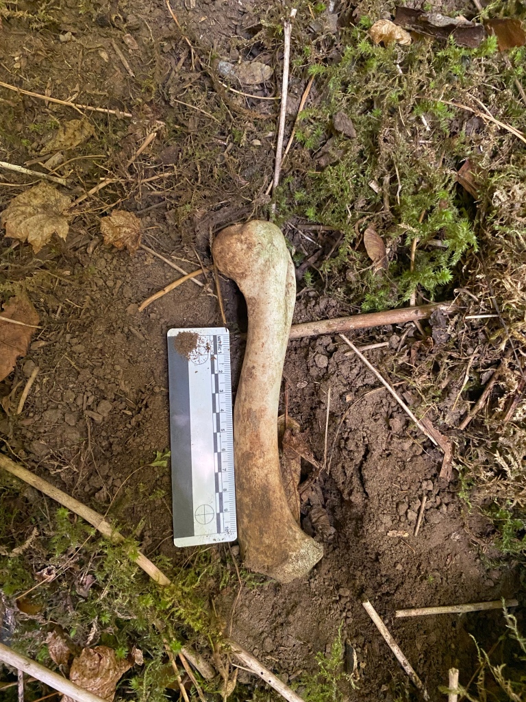
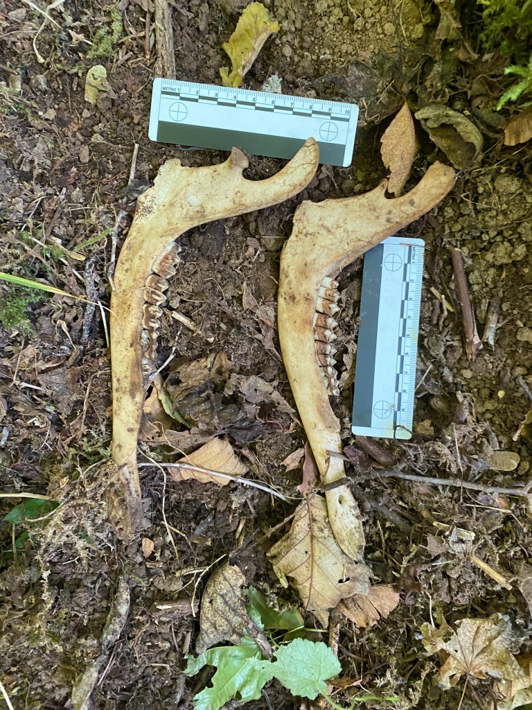
This area also produced the most amount of bones that I have found searching yet. I would like to thank Faith, Allison and Maddi for acting as an unofficial “bone phone” and helping me rule out definite animal remains. Here is an example of a bone fragment that I found that is actually from a deer.

Without their trained eyes, this animal part might have gone to LCSO. When I was examining it in the thicket what drew my attention is that the weathering and aging of the bone was remarkably similar to the material I recovered on 17 June at the Grissom site. Once I found it, I trekked out of the woods, drove back out to Highway 20 and texted the unofficial bone phone for ID help. Thank you all very much.
I returned after a short 20 minute break to a fresh rain shower, and an afternoon of being absolutely soaked from the wet and bloodied from the Devil’s Club. As Faith pointed out, at least I am in an area where animals take remains to scavenge on. I found a decent amount of an old elk skeleton back there was well. Due to the size of an elk, it is easy, even for me, to rule those out as potentially human.
I did find a bone fragment that we were unable to rule out as definitively animal, so this was called into the LCSO. It was a fragment, roughly 4x5cm that possibly came from the distal end of a radius, tibia or fibia. I compared the fragment to an exemplar, and it was close enough that I felt comfortable calling it in. Luckily, a LCSO patrol deputy exited Soda Fork Rd in a patrol rig while I was on the phone with dispatch. Instead of the usual 2-3 hour wait, it was only about 20 minutes while he turned around to come back. We had a great conversation about the work I’m doing, and the case itself. Hopefully I’ll hear soon on the State ME’s disposition of the bone.
Search Tools
“The only thing that beats new technology is no technology”.
Craig “Archie” Archer, Joint Exploitation Training Center, FT Bragg, 2011
These are the tools that I use for doing a search like this. To be honest, they are very basic tools, but they are dependable, low tech, and work in any weather. Different types of searches require different toolsets and general equipment. The equipment for an urban search for a lost child is much different from the packing list for going out to find a lost hiker on the Pacific Crest Trail. Below is a layout of what I typically take with me on a woodland remains search, like the one I am conducting for Karen and Rodney.
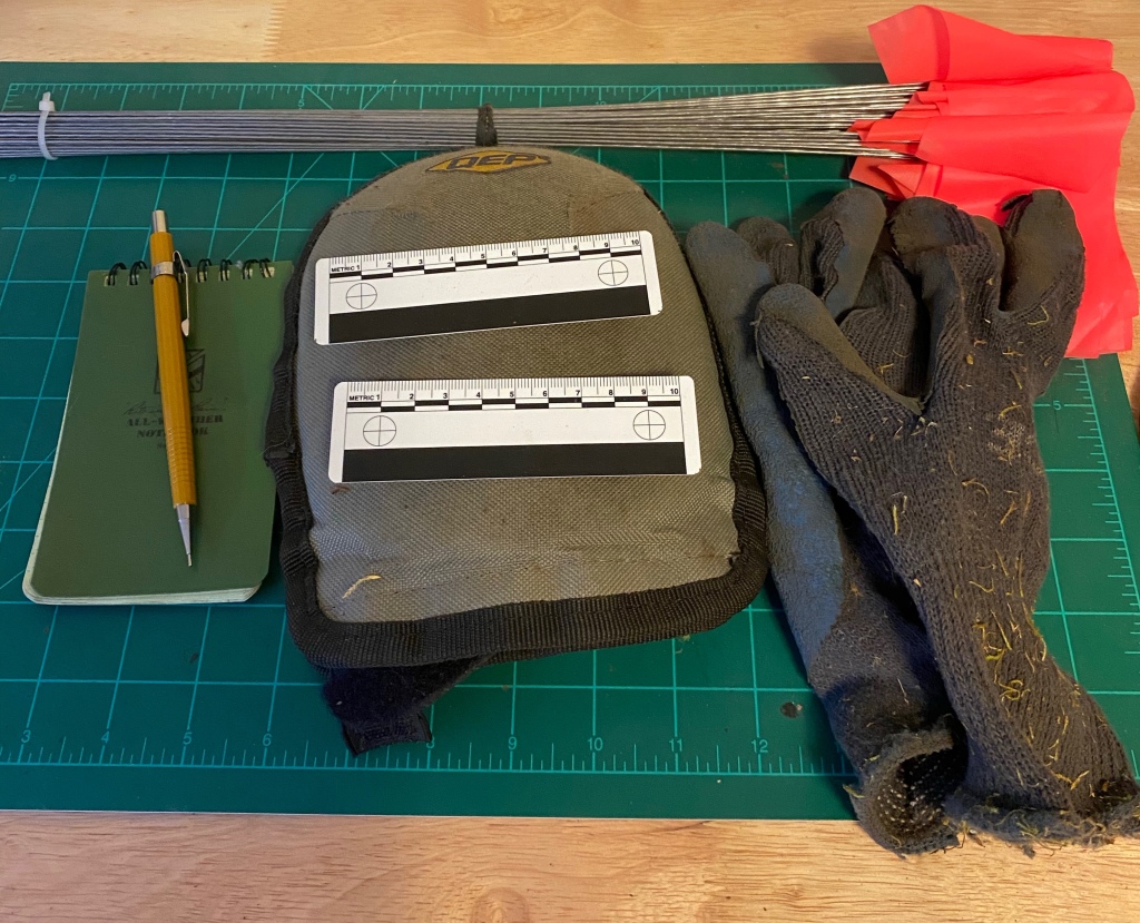
- All Weather Notebook and mechanical pencil: For sketching, making notes, etc. All weather notebooks are great for an environment like the PNW, and I greatly prefer pencils over pens for taking notes outside.
- Photogrammetric scales: These are used to provide a scale measurement for a photograph. This helps those examining the photograph determine the size, etc of the object in the photo. The inside cover of my notebook also has a scale. A dollar bill, 3×5” card, credit card, license, etc can also be used for a field expedient scale since they are all of a known size.
- Knee Pads: Self-explanatory for spending a full day working on your hands and knees. I prefer the soft foam type over the hardshell type. I find that the hardshell knee pads roll around too much on rocks or other hard surfaces. The soft, foam pads mold around rocks etc, and provide a lot more stability.
- Garden Gloves: Protect your hands from insects, thorns, plant irritants, etc. Garden gloves are far more durable than latex or nitrile gloves for a woodland search. I like the rubber dipped garden glove type. They are lightweight, dry fast since the cloth is synthetic and the rubber grip has a good “feel” to it. I find that the touch sensitivity of these allows me to differentiate between different types of material in my hands. These also prevent cross-contamination of any remains with touch DNA from my hands.
- Surveyor flags: I use these to mark search boxes, flag material for retrieval, mark trails to material, etc. Inexpensive, high vis and works in all weather.
- IPhone (not pictured): I use my iPhone for a camera, GPS, reference library and probably a few other uses I’m not thinking of at the moment. For my private searches I use the OnX GPS application. For a SAR call-out, I use SARTopo since our team has standardized on that and makes sharing tracks a breeze.
19 August Ground Search at the Lee Site
After last week’s roller coaster, we are back to the slow steady work of searching the Lee Site. It was another early Saturday morning and driving out to Soda Fork I noticed the extreme fire danger rating on the signs for every land manager with an office on US20. Luckily, there was very little to no smoke along Soda Fork.
The day began with me going over the same area where I recovered the animal bone fragment. Since that was where I finished , I wanted to overlap today’s search with that one. I also wanted to make sure in the work to document, photograph and mark the fragment, I didn’t miss anything else in the immediate area. After 45 minutes I was satisfied that the area from last week was clear, and I moved on to this week’s search box.

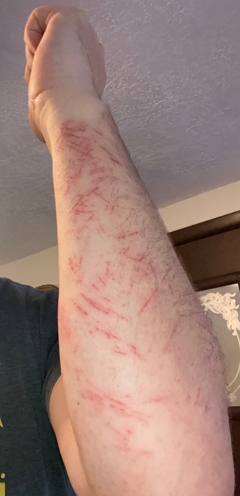
The area I searched was very thick alder and Devil’s Club thickets to the west, while it was slightly more open to the east, closer to the creek. This search may have been the most physically taxing for me. The ticket was tight enough that walking was impossible, at least if you’re trying to see the ground. I spent most of the day on my hands and knees, with a considerable distance spent high crawling on my stomach under the alders. My forearms are itchy from the natural mild irritant in the thorns of the Devil’s Club, my knees are aching and even my wrists feel the strain of supporting my upper body most of the day.


There were some areas that were relatively open, including one with a large alder. I pay a fair amount of attention to spots like this. Not only is the searching easier in the more open, less vegetated terrain, these also seem like likely areas to leave something. Without knowing what the landscape, lines of drift and “goat paths” looked like 46 years ago, I search these spots like they are potential crime scenes.

My plan for the next search is to go through the thicket that is outlined by the non-searched pocket between the turquoise, blue and purple tracks. That area has exceptionally thick vegetation, and it will be another search like yesterday’s- close to the ground and physically demanding.

Follow Up Post to the 12 August Search at the Lee Site
Linn County called me this afternoon and let me know that what I found Saturday was of animal origin. I am slightly disappointed but that just means we are going back to work at the Lee Site.
12 August Ground Search of the Lee Site
Much like the 17 June ground search at the Grissom site, this entry will lack a proper ending for a bit, although both days concluded with me waiting at the junction of US 20 and Soda Fork Rd for a Linn County Deputy to arrive.
The day began much as the previous 5 searches had. I arrived at the landing early, about 9am, and walked back to my first search location of the day. I skirted the edge of the swamp, then went to work in an area that was dry, but was at the same contour level as the swamp. It had the appearance as an area where debris collected, and I spent about 2 hours there going through the debris and looking under the ferns.
After completing my search of that area, I proceeded to the north and went past the “alcoves” I had searched the week prior and began working deeper in the alder thicket. I marked out with surveying flags a 50mx50m box before searching, and used the flags as my boundaries. After that box was searched, I was planning to mark out the next one, and keep repeating the process until the alder thicket was searched.
The vegetation of the thicket is tight enough that I knew that this search technique would take a lot of time to complete. It’s quite difficult to walk through it standing up, as it is so thickly grown in, it is easier to hunch over to walk, or just crawl. There was a large fallen tree within the search box, covered in moss, and was relatively easy to walk up to. In fact, taking the path from the landing to here is almost a straight shot, easy walking, and it “fits” with the description in the February 1978 article about the location where Karen’s clothing was found. I decided to use the tree as “12 o’clock” and started searching the ground from there.
After an hour, I was packing up, with a GPS waypoint marked and technical photograph on my phone of what I found. After a few hours wait, the Deputy and I trekked back into the forest, packaged the find, shook hands and we departed. I arrived home at 6pm, almost 12 hours after I left. It had been a long day, both physically and mentally.
